
Raptor Call 2024, by EIT Urban Mobility Incollaboration with Fingal County.

In 2024, DriveSimSolutions had the unique opportunity to contribute to improving active mobility and road safety in Fingal County by participating in the Quiet Streets challenge. This challenge, part of the CITY RAPTOR program, allowed us to apply our expertise to an impactful urban mobility solution.
The CITY RAPTOR program, funded by EIT Urban Mobility (an initiative of the European Institute of Innovation and Technology), fosters innovation by connecting cities with start-ups and SMEs to address urban mobility challenges. With a focus on agility and effectiveness, selected companies like ours had five months to develop and test a tailored solution.
Why DriveSimSolutions?
DriveSimSolutions was chosen for our versatile approach and proven track record in delivering integrated solutions. By leveraging advanced drone studies, we offered a comprehensive package, from research and data acquisition to evaluation and consulting. Our adaptable hardware and software enabled us to provide a robust and flexible plan that fully aligned with Fingal County’s needs.
How did we collect the data?
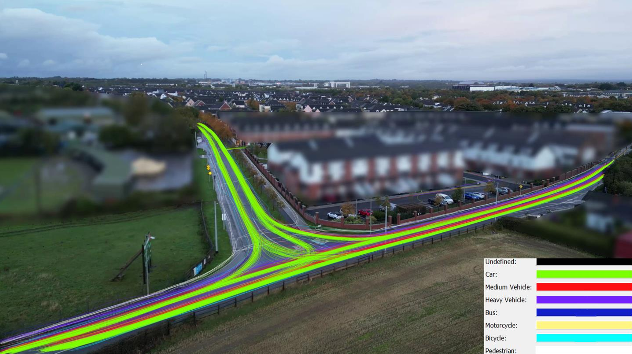
To address the challenge posed by Fingal County Council for evaluating the Quiet Streets initiative, we implemented one of the most effective and efficient solutions available at the time. Our approach combined drone technology with artificial intelligence, enabling the simultaneous observation of all required metrics through a single, integrated technique. This innovative method allowed us to collect high-quality, detailed data on various aspects of road use and air quality, ensuring comprehensive evaluation both before, during, and after the intervention.
Our solution was not only tailored to meet the needs of this specific project but was also designed to be easily replicable, making it ideal for similar evaluations in the future.
Data Collection and Analysis: What We Achieved
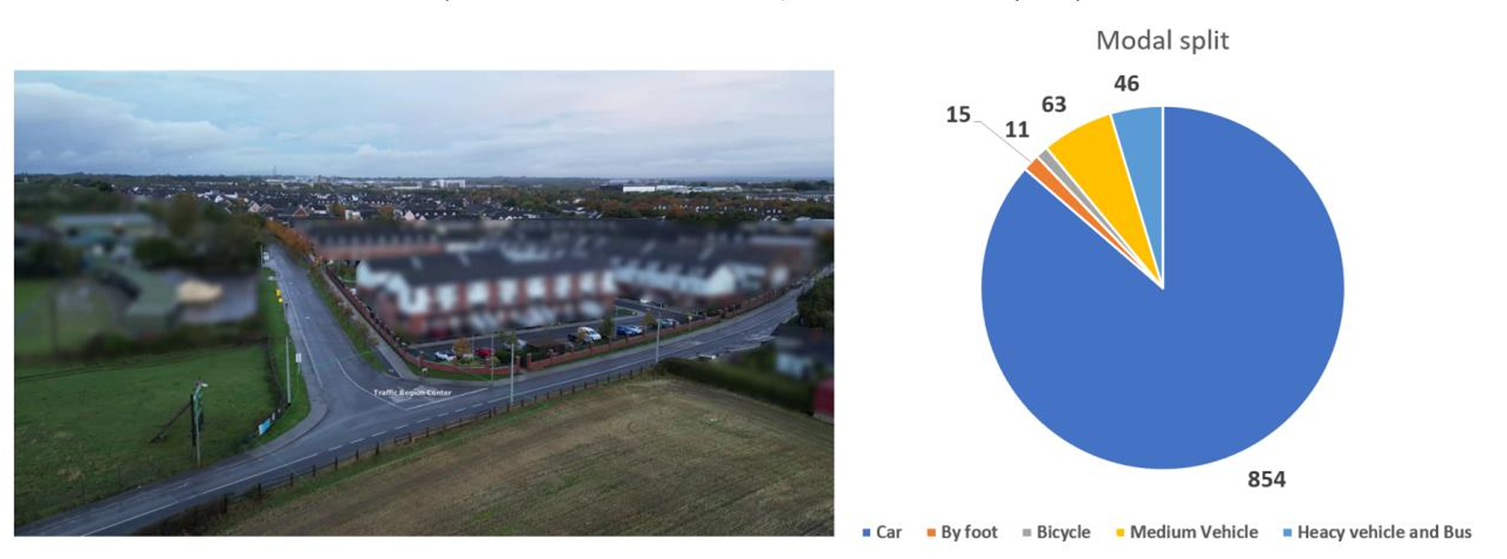
- Traffic Volume and Classification: We accurately counted and classified road users, including pedestrians, bicycles, motorcycles, cars, medium vehicles, buses, and heavy vehicles. Both raw data and aggregated reports were provided, ensuring precision in our traffic assessments.
- Modal Share Data: By applying advanced correction algorithms to the raw count data, we delivered accurate measurements of the modal share, revealing shifts in travel behaviour across user groups.
- Movement Dynamics:
- Detailed trajectories of all road users were recorded.
- We generated origin-destination matrices and detected near-conflict events based on parameters from scientific literature.
- Interesting dynamics, such as behavioural changes and near-conflicts, were automatically flagged and saved for deeper analysis and visual inspection.
- Speed Data: We provided detailed reports on speed metrics, including average speed, maximum and minimum speeds, and V85 speed. These were further segmented for specific road sections as needed.
- Event Detection and Compliance Monitoring: We detected and reported events such as illegal or hazardous parking and non-compliance with traffic regulations, offering detailed insights into user behaviours within the observation area.
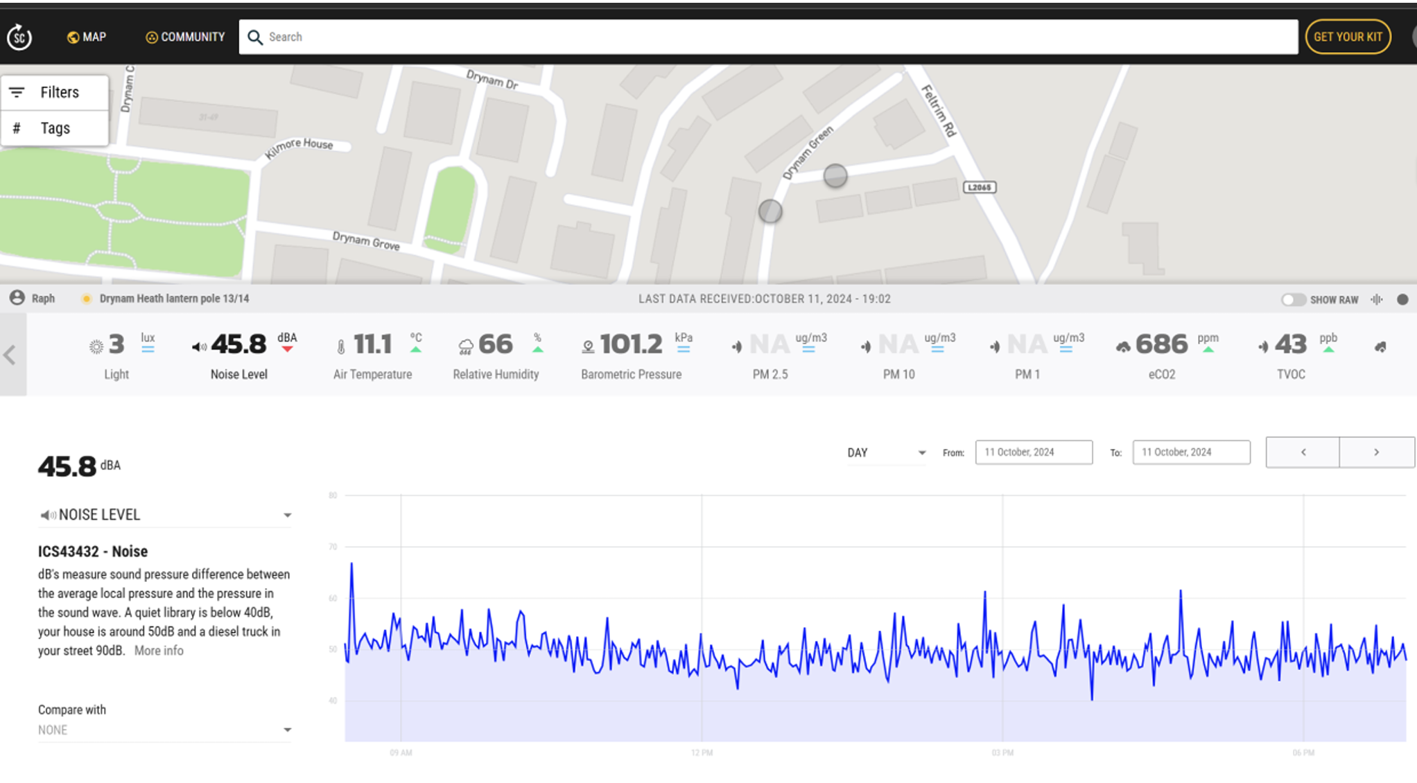
- Air Quality Data: Using street-level sensors, we overcame the limitations of drones at higher altitudes and captured accurate, localized air quality data.
- Video Data: We provided video footage of the observation areas, enabling further post-analysis and visual documentation of road use and behaviour.


Conclusion
The data collection process in Fingal County was a success, enabling us to achieve the objectives of the Quiet Streets initiative. Weather conditions, which play a critical role in capturing high-quality video footage, were fortunately favourable throughout the project. This allowed us to collect an extensive and detailed dataset, which served as the foundation for performing comprehensive analyses across a range of metrics, including traffic dynamics, modal share, user behaviour, speeds, and environmental impact.
We extend our heartfelt thanks to the CITY RAPTOR program, EIT Urban Mobility, and Fingal County for their support and the opportunity to collaborate on such an impactful project. The shared commitment to innovation and sustainable urban mobility made this partnership highly productive and rewarding.
This project represents a significant milestone in our mission to advance mobility solutions through cutting-edge technologies, such as drone-based data collection and AI-driven analysis. The insights gained not only demonstrate the potential of these techniques but also highlight their versatility and scalability. We aim to leverage this success by applying our proven methods in other cities, regions, and countries, adapting them to address diverse mobility challenges.
By continuing to implement these innovative approaches globally, we aspire to contribute to safer, more sustainable, and more liveable urban environments, ensuring that every project benefits from the expertise and lessons we’ve honed in Fingal County.
This project is supported by EIT Urban Mobility, an initiative of the European Institute of Innovation and Technology (EIT), a body of the European Union. EIT Urban Mobility acts to accelerate positive change on mobility to make urban spaces more liveable. Learn more: eiturbanmobility.eu
Recent Comments